Moab was a great spot - we were able to visit two national parks and one well-known state park from here.
Canyonlands NP is more or less across the highway (plus some driving) from Arches. But it's very different. The park covers the area where the Green River joins the Colorado from the north. There are three very different sections of the park - the high plateau (Island in the Sky) between the two rivers where you can look into the canyons carved by both rivers, a section called Needles (with hoodoos similar to Bryce Canyon), and a difficult to reach section called The Maze (mostly used by off-road vehicles). We limited our time to Island in the Sky.
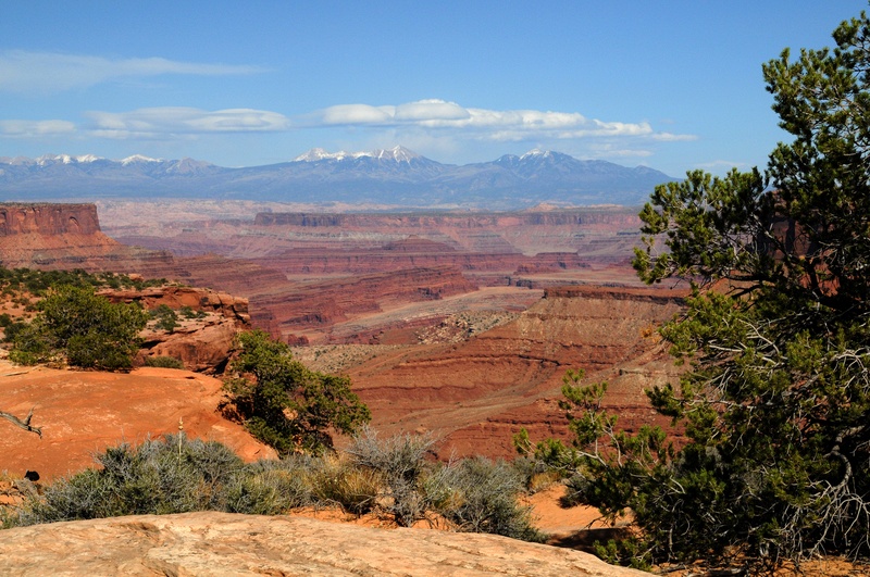
These pictures show the canyons made by the Green river.
We hiked to the top of Whale Rock. This is from the peak.
We also visited a area called Upheaval Dome. This is an interesting circular formation and it seems geologists are split on the reasons behind it. One school holds that there was a salt formation over a fault line and somehow a bubble rose up from underground. The other school believes that what we see today is the result of a meteor hit millions of years ago, but unlike Meteor Crater where we more or less see the surface of where the meteor hit, here we are seeing 1,000 feet below the surface and all that surface rock has eroded away. According to this explanation, the meteor was much larger than the one at Meteor Crater.
Canyonlands also has some arches. This was just a short hike off the road. It overlooks the canyons made by the Colorado river.
These are some additional views of the Colorado river side of the park. The river is about 2,000 feet below the canyon rim. This area was explored by John Wesley Powell, a one-armed Civil War veteran who was an official geologist for the US government. He was the first to go on the Colorado river all the way through the Grand Canyon. Lake Powell is named after him. He found lots of rapids just after the Green river joins the Colorado.
In the above picture, you can see the La Sal mountains. These also show up when looking through Delicate Arch (see previous post).
In the above picture you can see a vehicle heading down into the canyon. There are only dirt roads and they are used by motorcycles and off-road vehicles.
Very close to Canyonlands NP is a state park we had been advised to visit. This is Dead Horse Point State Park. It has great views of the Colorado river.
Matthew was able to get a Junior Ranger badge from Arches, Canyonlands, and Dead Horse Point. The parks also have combined to provide a "super" Junior Ranger, which they call a Red Rock Ranger program. This required Matthew to complete some additional requirements but then he was able to get another patch to add to his collection. We got this by going back to the visitor station at Arches. Here is Matthew will his full assortment of Jr. Ranger badges and pins, about 40. We are really proud of him for his work in getting all these.
Moab
We really enjoyed our time in Moab. We came here right after Bryce Canyon and things were like night and day. At Bryce, things were "off season" and some facilities were closed and the shuttle bus was not running. But when we arrived at Moab we were overwhelmed by the number of people there and the number of Jeep Wranglers. The folks at the RV park explained that for Moab, it was the peak of their tourist season. Lots of people go there for outdoor activities - hiking, off-road biking, motorcycling, ATVing, and Jeeping, as well as white-water rafting. Later in the year it gets too hot (except a lot of Europeans come in August). In addition to that, the weekend we were there Moab was hosing an old car show. During the day the cars were displayed in the park but Friday and Saturday evening the cars cruised up and down main street. It was quite a sight, and many of the locals crowded on the street side to see the show.
The Jeep people and motorcyclists also got in the action.
Did I mention that our RV park was right next to the street? In fact, the the previous picture there is a Texaco star in the background. Our RV was parked behind that sign! The cars were so noisy all evening! Fortunately they closed it down by about 10:30 so we could get some sleep.
Ah, the joys of living on the road! Always something new around the next corner.
Tuesday, May 8, 2012
Saturday, May 5, 2012
Arches National Park
It's May 5 - the day before Matthew's 10th birthday and he's as excited as can be. We're in northern New Mexico now, slowly headed home, and I need to catch up a little on the blog.
After Bryce Canyon National Park we drove across southern Utah to Moab, a little town I'll talk more about in the next post. There were some interesting things about the drive. We drove north from Bryce along a very pretty valley along the Sevier River. It turns out there are lots of outdoor activities on this river for locals and tourists - things like rafting, fishing, off-road riding, and so on. We joined interstate 70 (the same one that goes through Columbus) at mile marker 12 - it starts just to the west of where we joined. Driving across 70 was quite an experience. This part of southern Utah is very geographically diverse, with desert, plateaus, and deep canyons. There was a huge uplift (or something) along the way. Oh, there were also signs saying no services for 100 miles. Later I read in Wikipedia that this stretch of 70 is the least-serviced in the entire length of the highway!
Here's the uplift. Building a road through this proves the government can do pretty much anything it sets its mind to... (sometimes good, sometimes not so good...)
Moab was our base of operations for the next three or so days as we visited local national parks. First was Arches NP. There are over 2,000 arches in the park. They were formed by a unique combination of geological events hundreds of millions years ago as well as more "recent" events of 10 million years. Many of the formations have names. Here is Balanced Rock
If you look closely you can see two men climbing at the point where the rock touches the base. This gives you an idea of the scale. This one is Tower Arch.
This is Double Arch.
At about this time we had some back luck with weather - light rain. We decided to leave the park and drive along the Colorado River just north of Moab. The rain stopped and we had some fantastic scenery.
Awesome, awesome, awesome. Words just cannot describe this.
We were amazed by the 300 to 500 foot cliff walls along the river. There were also boaters. The river has a mixture of slow water and small white water at this point.
At this point the skies really opened up with rain. We had a very hard shower for 10 minutes or so. As we drove back to Moab we noticed waterfalls from the tops of the cliffs. These were spectacular. In this one you can see cars at the bottom of the waterfall.
The next day the weather was good and we had another go at Arches. We hiked up to Delicate Arch. This is an iconic image for Utah - it's on their license plates. We had to hike about a mile to get to the arch.
This is the arch as seen by looking through another arch!
Beth did some Photoshop work on this to remove all the people around it. It was a very popular place! You can see the snow-covered La Sal mountains in the background.
No Photoshop on this one. People all over the place!
We also did some other hiking.
These petroglyphs were along the way to Delicate Arch.
This is Landscape Arch. It's the longest (300 feet) in the US. About 10 years ago some visitors were filming the arch when a 60 foot chunk fell. No one was hurt and the event was captured on video. The trail no longer goes under the arch!
Another view of Balanced Rock, just because it's so amazing.
Matthew got a Junior Ranger badge (about number 36 or so for him). The next day we went to Canyonlands NP and Dead Horse Point State Park, but we'll save that for another post.
After Bryce Canyon National Park we drove across southern Utah to Moab, a little town I'll talk more about in the next post. There were some interesting things about the drive. We drove north from Bryce along a very pretty valley along the Sevier River. It turns out there are lots of outdoor activities on this river for locals and tourists - things like rafting, fishing, off-road riding, and so on. We joined interstate 70 (the same one that goes through Columbus) at mile marker 12 - it starts just to the west of where we joined. Driving across 70 was quite an experience. This part of southern Utah is very geographically diverse, with desert, plateaus, and deep canyons. There was a huge uplift (or something) along the way. Oh, there were also signs saying no services for 100 miles. Later I read in Wikipedia that this stretch of 70 is the least-serviced in the entire length of the highway!
Here's the uplift. Building a road through this proves the government can do pretty much anything it sets its mind to... (sometimes good, sometimes not so good...)
Moab was our base of operations for the next three or so days as we visited local national parks. First was Arches NP. There are over 2,000 arches in the park. They were formed by a unique combination of geological events hundreds of millions years ago as well as more "recent" events of 10 million years. Many of the formations have names. Here is Balanced Rock
If you look closely you can see two men climbing at the point where the rock touches the base. This gives you an idea of the scale. This one is Tower Arch.
This is Double Arch.
At about this time we had some back luck with weather - light rain. We decided to leave the park and drive along the Colorado River just north of Moab. The rain stopped and we had some fantastic scenery.
Awesome, awesome, awesome. Words just cannot describe this.
We were amazed by the 300 to 500 foot cliff walls along the river. There were also boaters. The river has a mixture of slow water and small white water at this point.
At this point the skies really opened up with rain. We had a very hard shower for 10 minutes or so. As we drove back to Moab we noticed waterfalls from the tops of the cliffs. These were spectacular. In this one you can see cars at the bottom of the waterfall.
The next day the weather was good and we had another go at Arches. We hiked up to Delicate Arch. This is an iconic image for Utah - it's on their license plates. We had to hike about a mile to get to the arch.
This is the arch as seen by looking through another arch!
Beth did some Photoshop work on this to remove all the people around it. It was a very popular place! You can see the snow-covered La Sal mountains in the background.
No Photoshop on this one. People all over the place!
We also did some other hiking.
These petroglyphs were along the way to Delicate Arch.
This is Landscape Arch. It's the longest (300 feet) in the US. About 10 years ago some visitors were filming the arch when a 60 foot chunk fell. No one was hurt and the event was captured on video. The trail no longer goes under the arch!
Another view of Balanced Rock, just because it's so amazing.
Matthew got a Junior Ranger badge (about number 36 or so for him). The next day we went to Canyonlands NP and Dead Horse Point State Park, but we'll save that for another post.
Wednesday, May 2, 2012
Bryce Canyon National Park
It's May 1 and my last post was a week ago! A lot has happened since then. We have visited four National Parks and a Utah state park. I need to catch up on the blog!
It's a short drive from Zion NP to Brice Canyon NP and a number of people we came across at Bryce had either just been to Zion or were going there next. Bryce is similar to Grand Canyon in that the main road is at the top of a canyon and you are looking down into the colorful canyon (unlike Zion where you mostly stay at the bottom of the canyon and look up at the walls and cliffs around you). But Bryce is much smaller than Grand Canyon and in many ways it's more accessible and intimate; maybe a little less intimidating. Hikes from the rim to the valley are only a change of 500 to 1,000 feet rather than the 5,000 feet of Grand Canyon.
Here's the requisite park entrance sign.
We stayed in an RV park just outside the NP. The "regular season" had not started yet for the park and some services (like a bus from the visitor center to the various viewing spots and trail heads) had not started yet. Similarly for the RV park. They have an outdoor pool but it was not filled yet. But we were allowed to use the indoor pool of the hotel that runs the RV park and we took advantage of that a few times. We had wonderful weather but it had snowed the week before we were there.
Here are the typical views into the canyon. There really is only one side of the canyon.
The interesting thing about Bryce is the many "hoodoos" that have been formed by erosion. They take lots of wonderful shapes and some are named, like "the Sentinel," "Queen Victoria," and "Thor's Hammer."
We took the Queen's Garden trail down from the rim. It was a descent of just over 300 feet and not very strenuous.
This gave us a chance to get up close and personal with the hoodoos. We also saw some mule deer in the valley part.
After a relatively flat trail through the valley we returned to the rim using a steeper trail, with lots of switchbacks. This gave us a chance to see "Thor's Hammer" and the "Three Princesses." Thor's Hammer shows up on a lot of postcards and posters of Bryce.
We probably have hundreds of images of Thor's Hammer (thank goodness we are not using film!), trying to get the "perfect" shot.
We had one rather "extended" day where we saw both the sun rise and sun set. The canyon faces east and so the sun rise light was better than the sun set (we've made a point of seeing sunsets at Sedona and the Grand Canyon and found them uninspiring and the same was true for Bryce).
I guess people get caught up in how the light moves across the hoodoos, but for some reason the conditions were not optimal for us.
Another "extended" event happened the first night we where there. A ranger conducted a talk about astronomy and light pollution and how it impacts viewing the stars and also nocturnal animals. We then went to the parking lot and were able to use telescopes owned by the park (one had a diameter of 15 inches).
We also took a trail that stayed at the top of the canyon. The elevation was 9,100 feet and we had great views into the canyon. We saw the remains of a tree that was estimated to have been 1,600 years old.
Yes, that's snow in various places.
One day we took an excursion east of the park. We saw a small waterfall.
Also, about 20 miles east of Bryce (driving along highway 12, a "scenic byway") we came across a huge peak rising a thousand or so feet above the road. This peak had been climbed by John Wesley Powell when he explored this area (he was the first to take a boat down the Colorado river as well). We learned that this is an area rich in dinosaur fossils.
We also learned some things that tied together some of the parks we have seen in this part of the country. They are all part of the "Colorado Plateau," but they have had different amounts of erosion. The more erosion that has taken place, the older the rocks that are visible. Beth modified some information we had and produced the following chart for Matthew to share with his class during our weekly Skype call.
Makes sense, right? If you would like a more detailed explanation, send us some email!
It's a short drive from Zion NP to Brice Canyon NP and a number of people we came across at Bryce had either just been to Zion or were going there next. Bryce is similar to Grand Canyon in that the main road is at the top of a canyon and you are looking down into the colorful canyon (unlike Zion where you mostly stay at the bottom of the canyon and look up at the walls and cliffs around you). But Bryce is much smaller than Grand Canyon and in many ways it's more accessible and intimate; maybe a little less intimidating. Hikes from the rim to the valley are only a change of 500 to 1,000 feet rather than the 5,000 feet of Grand Canyon.
Here's the requisite park entrance sign.
We stayed in an RV park just outside the NP. The "regular season" had not started yet for the park and some services (like a bus from the visitor center to the various viewing spots and trail heads) had not started yet. Similarly for the RV park. They have an outdoor pool but it was not filled yet. But we were allowed to use the indoor pool of the hotel that runs the RV park and we took advantage of that a few times. We had wonderful weather but it had snowed the week before we were there.
Here are the typical views into the canyon. There really is only one side of the canyon.
The interesting thing about Bryce is the many "hoodoos" that have been formed by erosion. They take lots of wonderful shapes and some are named, like "the Sentinel," "Queen Victoria," and "Thor's Hammer."
We took the Queen's Garden trail down from the rim. It was a descent of just over 300 feet and not very strenuous.
This gave us a chance to get up close and personal with the hoodoos. We also saw some mule deer in the valley part.
After a relatively flat trail through the valley we returned to the rim using a steeper trail, with lots of switchbacks. This gave us a chance to see "Thor's Hammer" and the "Three Princesses." Thor's Hammer shows up on a lot of postcards and posters of Bryce.
We probably have hundreds of images of Thor's Hammer (thank goodness we are not using film!), trying to get the "perfect" shot.
We had one rather "extended" day where we saw both the sun rise and sun set. The canyon faces east and so the sun rise light was better than the sun set (we've made a point of seeing sunsets at Sedona and the Grand Canyon and found them uninspiring and the same was true for Bryce).
I guess people get caught up in how the light moves across the hoodoos, but for some reason the conditions were not optimal for us.
Another "extended" event happened the first night we where there. A ranger conducted a talk about astronomy and light pollution and how it impacts viewing the stars and also nocturnal animals. We then went to the parking lot and were able to use telescopes owned by the park (one had a diameter of 15 inches).
We also took a trail that stayed at the top of the canyon. The elevation was 9,100 feet and we had great views into the canyon. We saw the remains of a tree that was estimated to have been 1,600 years old.
Yes, that's snow in various places.
One day we took an excursion east of the park. We saw a small waterfall.
Also, about 20 miles east of Bryce (driving along highway 12, a "scenic byway") we came across a huge peak rising a thousand or so feet above the road. This peak had been climbed by John Wesley Powell when he explored this area (he was the first to take a boat down the Colorado river as well). We learned that this is an area rich in dinosaur fossils.
We also learned some things that tied together some of the parks we have seen in this part of the country. They are all part of the "Colorado Plateau," but they have had different amounts of erosion. The more erosion that has taken place, the older the rocks that are visible. Beth modified some information we had and produced the following chart for Matthew to share with his class during our weekly Skype call.
Subscribe to:
Posts (Atom)