Friday, May 11, 2012

Glen Canyon, Lake Powell, Antelope Canyon and a stone

As we did for our visit to Yosemite, where we left the RV in a park and drove off with the Jeep and stayed in a lodge, we left Monument Valley and drove to Page, Arizona, to visit that area.

Over a week ago we had, visited Hoover Dam.  There is another dam farther farther up the Colorado River, at Glen Canyon.  The dam created Lake Powell (named for the one-armed John Wesley Powell who explored the Colorado River).  We spent the night in the lodge to be ready for a 7:30 AM boat ride to see Rainbow Bridge.

Here's the dam and some images of the lake.

 This is just downstream from the dam.  The canyon is about 500 feet at this point.

Here we are on the boat and some of the sights.


It's clear to see the high-water mark (sometimes called the "bath tub ring").  When the lake was first filled (it took 17 years), it was filled to the maximum point. The current level is about 50 feet below that.  The water bleached out the red rust from the stone!

There were lots of strange and wonderful shapes in the stone.


It was about a two hour ride up to Rainbow Bridge.  This is a true "bridge," created by a creek, as opposed to the many arches we saw at other parks.  It is huge.  Over 300 feet in height, the dome of the US capitol building could fit under it!
 To get an idea of the size, there are some people on a flat rock near the left side of the bridge.
 On our return, as we neared the harbor, it was interesting to see all the house boats.  It appears that water sides are mandatory!

Close to Page are some "slot canyons," very narrow canyons created by rivers.  We took a tour of one of these, Antelope Canyon. This is a favorite place for photographers because of the interesting groves in the sandstone and interesting lighting.

Our driver seemed to think she was the reincarnation of Mario Andretti as we tore across a sandy valley to get to the canyon.
 These images give an idea of what it's like in the canyon.


Our guide knew of special places to take pictures.  This is known as "the heart."
 We could also see a "sandfall" by tossing some sand up on the ledge.
 The following were also recommended by our guide.  Maybe leaning toward the artsy side.

We enjoyed our time at Page and area, but it was a two hour drive back to Monument Valley.  On the way, a stone hit our windshield and left a noticeable hole.  I guess that gave us more memories of Page!

Tuesday, May 8, 2012

Four Corners and Monument Valley

From Cortez, CO, we drove south and west to the Four Corners area.  This is the spot where four states come together - Utah, Colorado, New Mexico, and Arizona. It is located within the Navajo reservation.

Matthew was happy to be in four places at once!

There's not much else to do there, although we did some shopping from the various Navajo vendors, and we had Indian fry bread.  Yum.

Next stop was Monument Valley.  This is not a national park, but it is a special park within the Navajo reservation. Many movies, TV shows, and ads have been filmed here.  It has the iconic look of "the American west."


 We stayed in a place called Gouldings.  This is a lodge, RV park, trading post, and gas station named after Harry Goulding.  He and his wife had a trading post there in the 20s and 30s.  They convinced John Ford to make some John Wayne movies in Monument Valley, and as they say, the rest is history.

We took a tour with a Navajo guide.  We saw a traditional Navajo house called a Hogan.

The tour was in an open truck, over some pretty rough roads.  We all felt very dirty at the end of the tour, but it was worth it!

 We got to pretend to be cowboys!

We also saw arches and petroglyphs.


This last one is known as "Eagle's Eye."  Our guide had us lie down to get the full effect.
 One last image before we ride off into the sunset.  This was a beautiful place.

Mesa Verde

From Moab (Utah) we drove to Cortez Colorado, the closest town to Mesa Verde National Park, the next park on our plan.  This is a park with lots of cliff dwellings from Ancestral Pueblo native Americans (also called Anasazi, but that term is in decline).

The town of Cortez is in a valley and we enter the park from there.  But then we quickly drive up and up to the top of the mesa, perhaps 1,000 feet climb.  These are some views during the drive.


This is breathtaking scenery, but for Beth, what contributes most to the "breathtaking" is the sharp curves and steep dropoffs!

The park tells the story (to the extent that we know it) of a large group of people who lived in this area for 700 or so years (about 500 AD to 1200 AD).  In general, people are familiar with the cliff buildings, but the full story is that the Ancient Puebloans lived on the top of the mesa for most of their time here. They built "pit houses" and there are hundreds of the foundations still on the mesa.  They moved over the edge of the cliffs only for the last 200 or so years.  And then they left and there are some possible explanations for their move (like drought, soil exhaustion, or just a natural process of moving on...) but our impression is that no one is really sure of the exact reason for their departure.

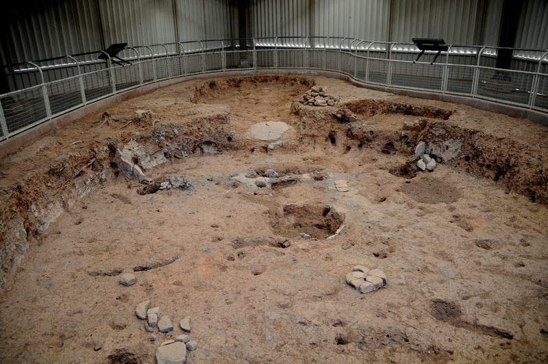
Here's an example of the remains of a pit house.

But most people are familiar with the cliff houses.  There are hundreds of them in this area and you can't help but be impressed with the efforts to build and live in these.  The people would farm on the top of the mesa and then live in the cliffs.  They had to scale the cliffs continually to get their crops and visit other people.

Some of the buildings were two and three stories high.  Also, the workmanship is very impressive, with nicely cut sandstone and very square edges on the buildings.  Because of the dry climate and protection by the cliff edge, a lot of the original construction still remains.  Here are some random images.


There was endless variation of the cliff dwellings - large, small, etc.  We did a self-guided tour of Spruce Tree House, the third-largest village.  One element of all the buildings is a "kiva," a circular room used for ceremonies.  Matthew was able to explore one.


We also did a Ranger-lead tour of Cliff Palace, the largest village.  We had to descend about 100 feet of stairs to get there.


It was fascinating to see the buildings an learn more about these people.  But we also experienced the "law of trails" that if you go down, eventually you have to go back up.  Here we are on the multiple ladders to return to the mesa top.

The original inhabitants did not have these ladders.  They carved small (very small) steps into the rock.  Here's an example.
We were happy the Park Service provided the ladders!